News

Graduate Research Assistant Position

Graduate Research Assistant Position

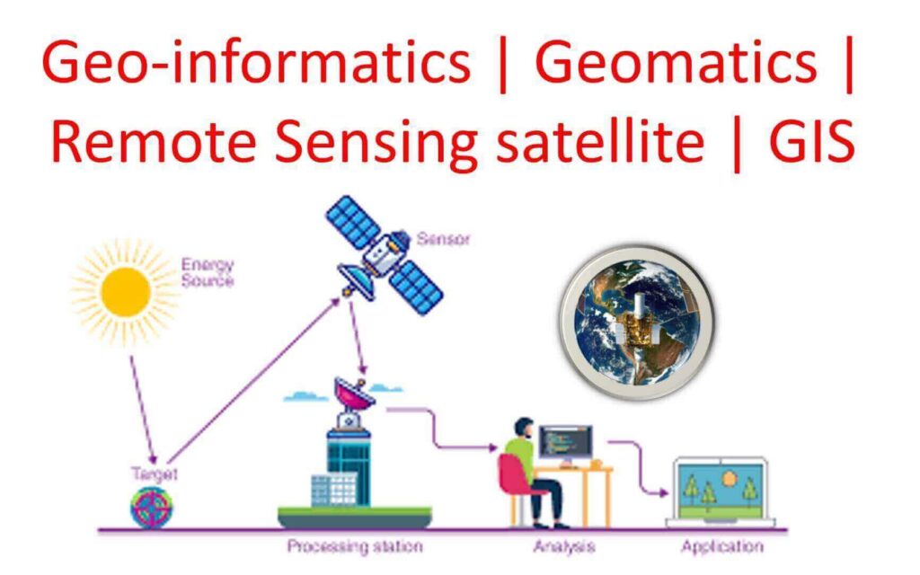
North Dakota State University is inviting applications for the Graduate Research Assistant Position Another graduate research assistant position will be available for the Spring semester of 2025. Key Requirements:1)  Field Robotics & Drone for Agriculture2)  Mechatronics3)  GIS & Satellite Remote Sensing4)  Mastery in Programming: programming prowess in Python5)  Image processing 6)  Machine Learning Applications7)  Independence and Initiative: an independent and self-initiative working attitude8)  Well-organized working […]

Graduate Research Assistant Position Read More »

Blender GIS: Explore 3D Mapping and Visualization

Blender GIS is a powerful open-source software that seamlessly combines the capabilities of Blender, a renowned 3D modeling and animation tool, with the functionalities of a Geographic Information System (GIS). With Blender GIS, users can effortlessly import, visualize, and analyze spatial data within a 3D environment, unlocking a world of possibilities for creating stunningly realistic

Blender GIS: Explore 3D Mapping and Visualization Read More »

Top 10 GIS Software

Here is the list of Top 10 GIS Software programs, along with a brief overview of each program and its features. GIS (Geographic Information System) software is a powerful tool used for capturing, managing, analyzing, and displaying geographical data. It allows users to integrate various types of data, such as maps, satellite imagery, aerial photographs,

Top 10 GIS Software Read More »

Geoinformatics | Geomatics | Remote Sensing Satellite | GIS

Geoinformatics | Geomatics | Remote Sensing Satellite | GIS

I. Brief (Geoinformatics | Geomatics | Remote Sensing Satellite | GIS) A. Introduction to Geoinformatics Geoinformatics is an interdisciplinary field that combines geospatial technology, computer science, and data analysis to study and understand the Earth’s physical and social systems. It is a powerful tool that enables us to map, analyze, and visualize spatial data to

Geoinformatics | Geomatics | Remote Sensing Satellite | GIS Read More »

Standard Operating Procedures of Drone Survey in Mine Area, GoI

Standard Operating Procedures of Drone Survey in Mine Area, GoI. Standard Operating Procedures under sub rule (5) of rule 34A of MCDR, 2017 for carrying out Drone Survey and submission of Digital Aerial (Drone & Satellite) Images of Mining areas to Indian Bureau of Mines. To leverage the use of technology, it has been proposed

Standard Operating Procedures of Drone Survey in Mine Area, GoI Read More »

ESRI Shapefile

ESRI Shapefile | Free Shapefile Download|Arcgis File Download

ESRI Shapefile is a file format that is widely used in the field of geographic information systems (GIS) to store and manage spatial data. It is a vector data format that can represent point, line, or polygon features, along with their associated attributes. In this article, we will discuss the features, benefits, and limitations of

ESRI Shapefile | Free Shapefile Download|Arcgis File Download Read More »

Global Positioning System |GPS

Global Positioning System|GPS

Global Positioning System, also known as GPS, is a satellite-based navigation system that is used to determine the location and time information of an object or person on or near the Earth’s surface. GPS has become an essential tool for a variety of applications, from navigating a car to tracking wildlife movements. History of GPS

Global Positioning System|GPS Read More »

Space weather effects article| ESA Academy

Apply for ESA Academy’s brand new Space Weather Training Course

In brief ESA Academy is proud to announce that university students may now apply for the pilot edition of the Space Weather Training Course, to be held from 8 to 12 May 2023 at ESA Academy’s Training and Learning Facility in ESEC-Galaxia, Belgium. This training course has been developed by ESA’s Education and Space Weather Offices.  In-depth Did you

Apply for ESA Academy’s brand new Space Weather Training Course Read More »

ESA-1

The European Space Agency (ESA): 7th ADVANCED TRAINING COURSE ON RADAR POLARIMETRY

The European Space Agency (ESA) is organizing the 7th ESA Advanced Course on Radar Polarimetry for training the next generation of Earth Observation (EO) scientists in dual and fully polarimetric data for science and applications development. The course is part of ESA’s EO Science for Society â€“ the Scientific Exploitation element of EOEP-5 (the fifth cycle of ESA’s

The European Space Agency (ESA): 7th ADVANCED TRAINING COURSE ON RADAR POLARIMETRY Read More »

flood mapping with satellite

Tending method for identifying and mapping flood extent and flood-affected paddy rice fields | GEE Code available

Flood: a natural disaster Flooding is a recurring natural disaster in the Indian subcontinent, affecting millions of people’s lives, infrastructures, economics, and local ecosystems. The country’s geographical and riverine structures increase the risk of flooding, making it prone to devastating floods. Moreover, rapid unplanned urbanization, climate change, changes in land use/land cover (LULC), and irregular

Tending method for identifying and mapping flood extent and flood-affected paddy rice fields | GEE Code available Read More »

Ads Blocker Image Powered by Code Help Pro

Ads Blocker Detected!!!

We have detected that you are using extensions to block ads. Please support us by disabling these ads blocker.

Powered By
Best Wordpress Adblock Detecting Plugin | CHP Adblock