
Mahatma Gandhi Employment Guarantee Act 2005 (or, NREGA No 42, later renamed as the “Mahatma Gandhi National Rural Employment Guarantee Act” or MGNREGA), is an Indian labour law to livelihood security of people in rural areas by guaranteeing hundred days of wage-employment in a financial year to a rural household whose adult members volunteer to do unskilled labour work.
Now, Govt. of India launches new Geospatial Planning Portal under geoportal Bhuvan, named ‘Yuktdhara’ (Yukt’ is derived from Yojanam, the planning and ‘Dhara’ indicates the Flow) to facilitate Planning of New MGNREGA assets using geospatial technology. “This platform will serve as a repository of assets (Geotags) created under various national rural development programmes, i.e., MGNREGA, Integrated Watershed Management Programme, Per Drop More Crop and Rashtriya Krishi Vikas Yojana etc., along with field photographs (23/08/2021 by PIB Delhi)”
It is a joint effort of ISRO and Ministry of Rural development made towards realising a G2G service for rural planning in support of decentralized decision making.
This portal integrates wide variety of thematic layers, multi-temporal high resolution earth observation data with analysis tools. Planners will analyse previous assets under various schemes and facilitates identification of new works using online tools. Plans prepared will be evaluated by appropriate authorities under State Departments. Thus, Yuktdhara based plans will be prepared by grassroot functionary and verified by appropriate authorities for relevance and resource allocation. This would ensure quality of plan and enable a long term monitoring of the assets created over the years.
The Minister pointed out that GeoMGNREGA on Bhuvan has received wide acclaims. The Before-During-After Geotagging of assets has successfully implemented the progress based disbursement of the funds during the process of creation of rural assets. Also, a Citizen-centric Mobile Application JANMANREGA has helped rural population for providing feedback using Bhuvan services. He was of the view that the synergy of Geographic Information and Earth Observation technology has not only brought the value of location to each rural asset, but also brought in unprecedented transparency in MGNREGA programme.
GeoMGNREGA database is noteworthy and is a first of its kind massive exercise in the whole world.
Govt. of India Launches Geospatial Planning Portal, ‘Yuktdhara – MGNREGA assets
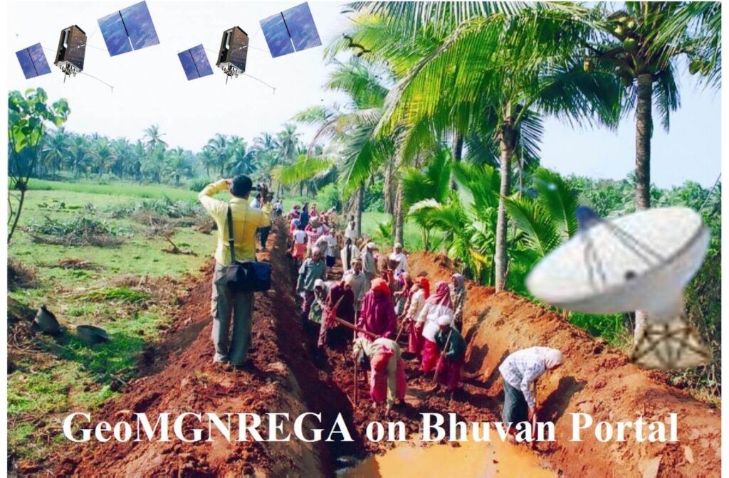
GeoMGNREGA:
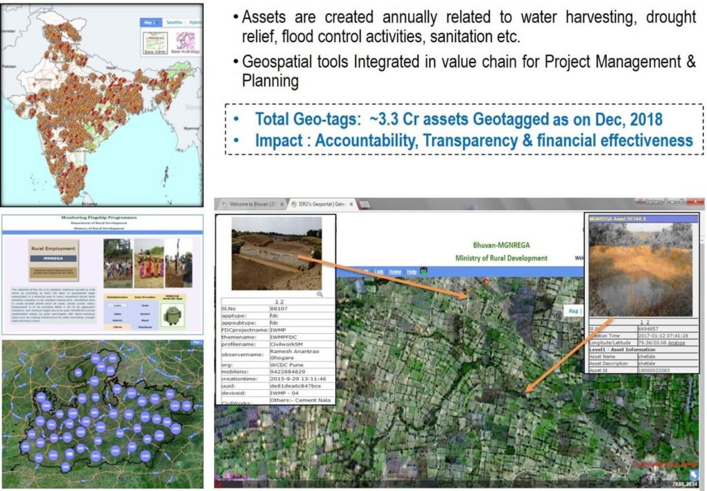
Mahatma Gandhi National Rural Employment Guarantee Act (MGNREGA) aims at livelihood security of people in rural areas by guaranteeing hundred days of wage-employment in a financial year to a rural household whose adult members volunteer to do unskilled labour work. The Mahatma Gandhi NREGA sponsors various schemes for helping rural people below the poverty-line for creation of wage employment and productive assets. As per the information available with NREGASoft, around 30 lakh assets are created annually during a financial year under Mahatma Gandhi NREGA. Ministry of Rural Development proposes to use GIS solutions to visualize, analyse and explore such asset related data and also manage them more effectively along with better understanding of their impact/outcome.
Government agencies like Department of Land Revenue, PMKSY, etc., have taken advantage of information technology and widely used it to store and maintain asset information.
Remote Sensing (RS) and Geographical Information System (GIS) can be effectively used to collect, store and analyse Mahatma Gandhi NREGA assets (Watershed locations, farm ponds, percolation tanks, check dams, road layer, irrigation channels, etc.). With the use of GIS in the area of asset management, it is possible to visualise and understand the geographical context of an asset and improve the efficiency of asset management. Spatial location is a major common aspect of all the asset data and GIS can map all the assets along with information for visualisation and proper decision making.
The Mahatma Gandhi NREGA GIS Solution intends to provide a single and integrated view of asset information system pan rural India. GIS enabled portal (e-Governance) will act as a gateway to facilitate and coordinate the exchange and sharing of geospatial data between stakeholders from various jurisdictional levels in the spatial data community. This will facilitate to search, locate and publish geospatial data wherein end users can access, share and publish (with appropriate log-in authenticity) in response to the needs of diverse user groups. The GIS enabled portal will maintain, process, store, distribute and improve the utilisation of geospatial data for planners, decision makers and public.
Scope of Work of Mahatma Gandhi NREGA Geographical information system:
- Geo-referencing of satellite images and scanned images (assigning real world coordinates)
- GIS Mapping – Creation of Digital data (Assets) for pan rural India for specified works as specified in schedule I of MGNREGA Act.
- Design and Development of Centralised GIS Data Model (Spatial and Non-Spatial Layers) to store spatial and attribute information.
- Facilitate periodic capturing / updation / maintenance of existing asset information using Mobile GIS platform
Geotagging of images and integrating with respective assets - Publishing of the asset information using Web Mapping Service (WMS) for citizens to visualise
and give feedback in a crowd-sourcing architecture.
GIS Implementation Strategy in MGNREGA:

Important links of GeoMGNREGA:
Yuktdhara Portal: Click here
Bhuvan-MGNREGA: Click here
GeoMGNREGA Grid Based Spatial Analytics: Click here
FAQ:
What is GeoMGNREGA?
GIS implementation of MGNREGA (GeoMGNREGA) Government of India enacted MGNREGA to enhance the livelihood security of rural people.
Is it MGNREGA or NREGA?
Mahatma Gandhi Employment Guarantee Act 2005 (or, NREGA No 42, later renamed as the “Mahatma Gandhi National Rural Employment Guarantee Act” or MGNREGA), is an Indian labour law to livelihood security of people in rural areas by guaranteeing hundred days of wage-employment in a financial year to a rural household whose adult members volunteer to do unskilled labour work.
What is the role of Remote Sensing and GIS in MGNREGA?
Remote Sensing (RS) and Geographical Information System (GIS) can be used to map the MGNREGA assets like Watershed locations, farm ponds, percolation tanks, check dams, road layer, irrigation channels, etc.).
What is Yuktdhara?
Govt. of India launches new Geospatial Planning Portal under GeoPortal Bhuvan, named ‘Yuktdhara’ (Yukt’ is derived from Yojanam, the planning and ‘Dhara’ indicates the Flow) to facilitate Planning of New MGNREGA assets using geospatial technology.
What is the geospatial planning portal of ISRO?
It is a WebGIS platform for finding geographic information of existing utilities and also has the ability to display, edit, analyze the geographic information. It is a joint effort of ISRO and Ministry of Rural development made towards realising a G2G service for rural planning in support of decentralized decision making.
