Flood: a natural disaster
Flooding is a recurring natural disaster in the Indian subcontinent, affecting millions of people’s lives, infrastructures, economics, and local ecosystems. The country’s geographical and riverine structures increase the risk of flooding, making it prone to devastating floods. Moreover, rapid unplanned urbanization, climate change, changes in land use/land cover (LULC), and irregular rainfall are the main causes of recurring floods.
Geographical and Riverine Structures
The Indian subcontinent is home to numerous rivers, including the Brahmaputra, Ganges, and Indus. These rivers, along with their tributaries, provide water for irrigation and support millions of people’s livelihoods. However, the same rivers also pose a significant risk of flooding during monsoons due to their extensive drainage basin and low-lying delta regions.
Causes of Flooding
Rapid unplanned urbanization and changes in LULC have altered the natural flow of water, leading to increased surface runoff and reduced infiltration. As a result, there is less water available to recharge groundwater aquifers, which reduces the country’s resilience to droughts and exacerbates the impact of floods.
Climate change is also exacerbating the impact of floods in the Indian subcontinent. Warmer temperatures are causing glaciers to melt rapidly, leading to an increase in river flow during the monsoon season. This can lead to more severe floods, causing damage to crops, infrastructure, and livelihoods.
Irregular rainfall patterns are also contributing to the recurrence of floods. A changing climate means that the timing, intensity, and duration of rainfall are unpredictable, leading to flash floods that catch people off guard and cause widespread damage.
Impact of Flooding
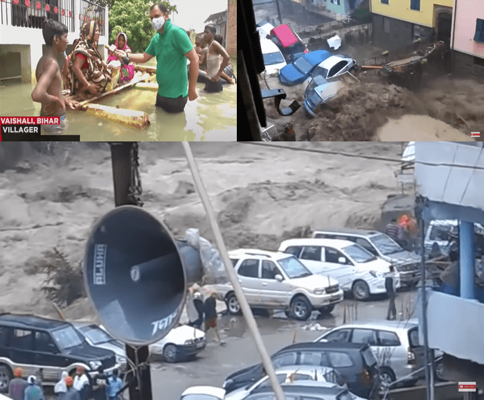
The impact of flooding on people’s lives is significant, forcing them to evacuate their homes and migrate to other areas. This has a devastating effect on the local economy, with agriculture and small businesses often being the hardest hit.
Infrastructure, such as roads and bridges, is also severely affected by flooding. Damage to infrastructure disrupts the movement of goods and people, causing long-term economic damage.
Local ecosystems are also impacted by flooding. Waterlogging, soil erosion, and sedimentation affect the quality of the soil, reducing crop productivity and biodiversity.
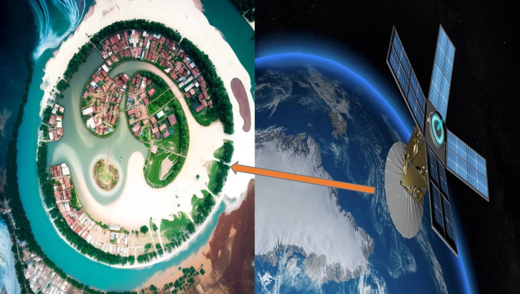
Remote Sensing satellite for Flood Mapping
Remote sensing satellite data has been used over the years to monitor floods in real-time. This technology is capable of detecting flood extent, intensity, progression, and deterioration. Synthetic Aperture Radar (SAR) data is particularly useful for flood mapping as it has an advantage over multispectral optical data due to its all-weather and day-night sensing capability.
In 2014-2016, the European Space Agency (ESA) launched the Sentinel-1A/B satellites. This was the first-ever global SAR mission, and its datasets are open access for the global public and researchers. The Sentinel-1 mission has a spatial resolution of 10 meters and a temporal resolution of six days, which helps in rapid flood mapping within a short time frame.
Operational Use of Remotely Sensed Data for Disaster Management
Remotely sensed Earth Observation (EO) data and products have been used for monitoring flooded regions and are gradually being used in operational purposes for disaster management. The spatial and temporal characteristics of remote sensing data allow for the acquisition of essential information from geomorphological features of rivers, which can be beneficial for mitigation measures during disasters.
Availability of Satellite Data
Multiple sources of satellite data are freely available (Sentinel-1, Sentinel-2, Landsat, Modis, LISS, etc) for different types of analysis. However, due to resource unavailability, downloading, storing, and processing satellite data can be a challenging task for users.
To Overcome the Challenges:
Google Earth Engine (GEE) for Remote Sensing Data Processing
To overcome the challenges associated with the downloading, storing, and processing of remote sensing data, Google launched the Google Earth Engine (GEE) platform. This cloud-based geospatial processing platform provides access to high-performance computational resources for processing satellite data without the need for local storage. Additionally, it allows up-to-date remote sensing databases to be used for scientific and academic purposes, and users can share their developed codes with multiple users and researchers.
Overview of Google Earth Engine
The Google Earth Engine (GEE) platform was introduced by Google, Inc. as a new computing platform for large-scale data processing, such as the time-series data analysis of Landsat archive. The platform provides access to a vast archive of satellite data and enables users to process this data at scale. The platform is designed to allow users to run complex analyses on large datasets quickly and easily, without the need for advanced technical expertise or specialized hardware.
Advantages of Using Google Earth Engine
One of the main advantages of using GEE is that it provides access to a vast archive of satellite data, including the Sentinel-1A/B Ground Range Detected (GRD) data. This archive is updated regularly, ensuring that users have access to the most up-to-date data available. GEE also provides access to pre-built algorithms, which can be used to perform common remote sensing analyses, such as land cover classification or change detection.
GEE also provides an interface for users to write their own scripts using the JavaScript programming language. This interface is designed to be user-friendly and intuitive, allowing users to quickly develop custom scripts for their specific analysis needs. Additionally, GEE has a collaborative platform that allows users to share their scripts and analyses with other users, which can facilitate collaboration and knowledge sharing.
Another significant advantage of using GEE is that it provides high-performance computing resources for processing remote sensing data. This eliminates the need for users to invest in specialized hardware or software to process large datasets. Additionally, GEE is designed to run on Google’s cloud infrastructure, which is highly scalable, ensuring that users can process large datasets quickly and efficiently.
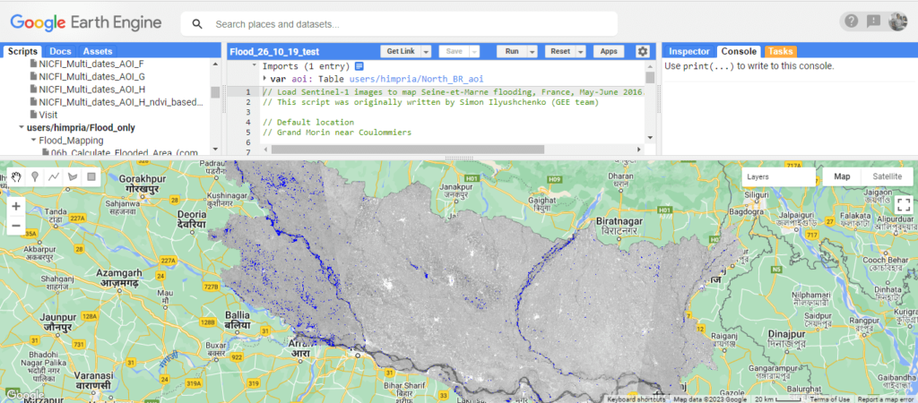
Flood Mapping Google Earth Engine Code:
var Him = ee.ImageCollection(‘COPERNICUS/S1_GRD’) .filter(ee.Filter.listContains(‘transmitterReceiverPolarisation’, ‘VV’)) .filter(ee.Filter.eq(‘instrumentMode’, ‘IW’)) .select(‘VV’) .map(function(image) { var edge = image.lt(-30.0); var maskedImage = image.mask().and(edge.not()); return image.updateMask(maskedImage); }); var desc = Him.filter(ee.Filter.eq(‘orbitProperties_pass’, ‘DESCENDING’)); var summer = ee.Filter.date(‘2020-07-24’, ‘2020-08-28’); var descChange = ee.Image.cat( desc.filter(summer).mean()); Map.setCenter(84.47261294117197,26.512402731644276, 8); Map.addLayer(descChange, {min: -25, max: 5}, ‘Target layer’, 1); ///// ////Citation: Kumar, H., Karwariya, S.K. & Kumar, R. Google Earth Engine-Based Identification of Flood Extent and Flood-Affected Paddy Rice Fields Using Sentinel-2 MSI and Sentinel-1 SAR Data in Bihar State, India. J Indian Soc Remote Sens 50, 791–803 (2022). https://doi.org/10.1007/s12524-021-01487-3Summary:
flooding is a widespread, natural disaster in the Indian subcontinent, affecting millions of people’s lives, economies, and local ecosystems. The country’s geographical and riverine structures, rapid unplanned urbanization, climate change, changes in LULC, and irregular rainfall are the main causes of flooding. The impact of flooding is severe, with people forced to evacuate their homes and migrate to other areas, causing long-term economic damage. Therefore, there is an urgent need to implement effective flood management strategies that include measures to reduce the risk of flooding, protect infrastructure, and support local communities.
The Google Earth Engine (GEE) platform is an advanced cloud-based geospatial processing platform that provides access to high-performance computational resources for processing satellite data. It is designed to enable the processing of large-scale datasets quickly and efficiently, without the need for advanced technical expertise or specialized hardware. The platform provides access to a vast archive of satellite data, including the Sentinel-1A/B Ground Range Detected (GRD) data, and enables users to develop custom scripts for their specific analysis needs. Additionally, GEE has a collaborative platform that facilitates knowledge sharing and collaboration among users. The use of GEE has revolutionized the way remote sensing data is processed, and its availability has significantly improved the accuracy and efficiency of remote sensing data processing.
Source:
Kumar, H., Karwariya, S.K. & Kumar, R. Google Earth Engine-Based Identification of Flood Extent and Flood-Affected Paddy Rice Fields Using Sentinel-2 MSI and Sentinel-1 SAR Data in Bihar State, India. J Indian Soc Remote Sens 50, 791–803 (2022). https://doi.org/10.1007/s12524-021-01487-3
 Geospatial Bill of India 2022
 NAAS Score of Science Journals (Effective from January 1, 2019, 2021, 2022)| NAAS Rating
 IIRS, ISRO: Engagement of Technician (Diploma Holders) & Graduate (Engg. / Tech.) Appr
 Govt. of India Launches New Geospatial Planning Portal, ‘Yuktdhara’ to facilitate Planning of
  ISRO Inviting proposal: To utilize Chandrayaan-2 Orbiter Payloads data for scientific analysis