
Important Facts about Landsat 9 Satellite
| Science Instruments: | OLI-2; TIRS-2 |
| OLI-2 build: | Ball Aerospace & Technology Corp. |
| TIRS-2 build: | NASA Goddard Space Flight Center |
| Design Life: | 5 years |
| Spacecraft Provider: | Northrop Grumman |
| Image Data: | > 700 scenes per day |
| Launch Date: | Sept. 27, 2021 |
| Launch Vehicle: | United Launch Alliance Atlas V 401 |
| Orbit: | near-polar, sun-synchronous at an altitude of 438 miles (705 km) |
| Orbital Inclination: | 98.2˚ |
| Spacecraft Speed: | 16,760 mi/hr (26,972 km/hr), |
| Consumables: | 10 years |
Landsat-9 is the latest remote sensing satellite of the Landsat series. which was launched on 27 September 2021 at 1:12 PM CST from Vandenberg Air Force Base, California, on-board a United Launch Alliance Atlas V 401 rocket. It will continuously capture images of Earth’s surface, returning back data on natural and man-made changes to our planet. Landsat 9 largely replicates its predecessor Landsat 8 to reduce the build time and a risk of a gap in observations.

Landsat 9 has two science instruments, which are the same instruments as the Landsat 8 satellite but with some improvements.
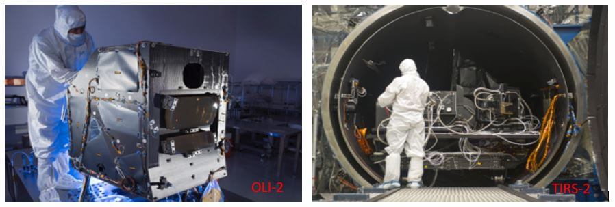
Operational Land Imager-2 (OLI-2) for reflective band data.
OLI-2 has made by Ball Aerospace in Boulder, Colorado, U.S.A. Which will capture observations of the planet in visible, near-infrared and shortwave-infrared light. It is also a slightly improved signal-to-noise ratio over Landsat 8’s OLI.
Thermal Infrared Sensor-2 (TIRS-2) for the thermal infrared bands.
TIRS-2 will measure the thermal infrared radiation, or heat (brightness temperature), of Earth’s surfaces. The instrument was built at NASA Goddard Space Flight Center in Greenbelt, Maryland. TIRS-2 will provide an upgraded version of the Landsat 8 TIRS instrument, by improving reliability and correcting known issues with stray light.
It is a Class-B instrument with a (05) five-year design life and a key improvement of stray light correction, an issue that was discovered on Landsat 8’s TIRS (Landsat 8’s TIRS is a Class-C instrument with a three-year design life).
- Landsat 9 has sophisticated imaging capability than earlier Landsat missions, which will allow for more valuable Earth observations.
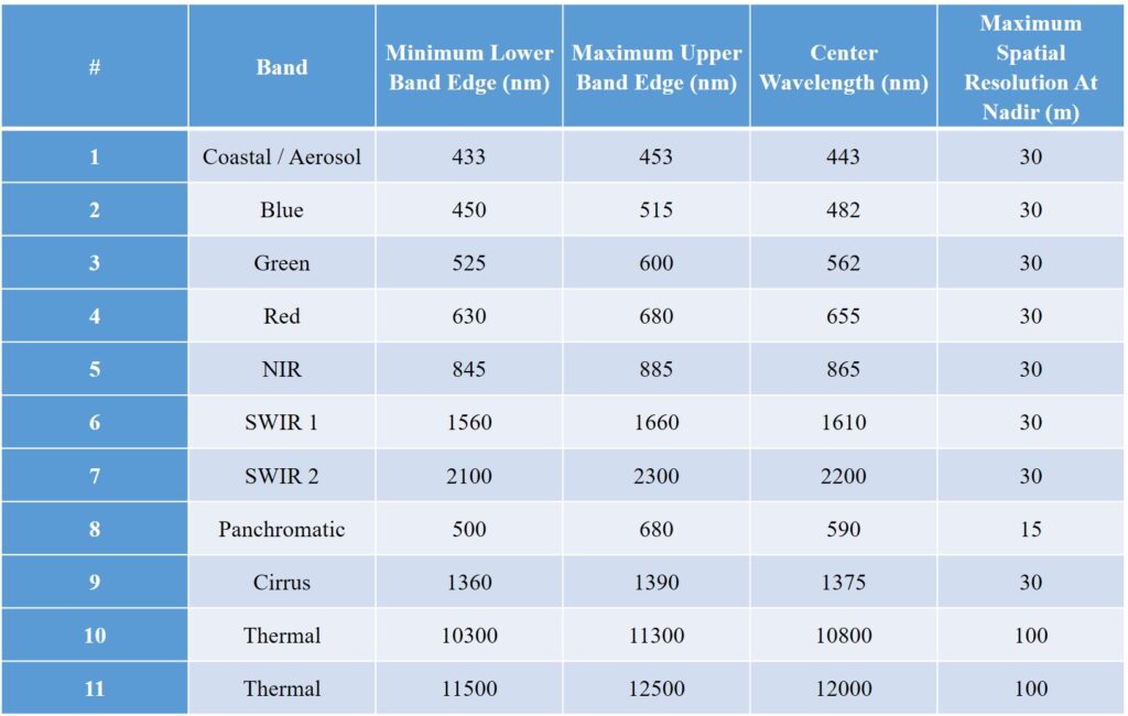
- Both instruments have sensors with moderate spatial resolution—15 m (49 ft), 30 m (98 ft), and 100 m (328 ft) depending on spectral band—and the ability to detect a higher range in intensity than Landsat – 8. Landsat-9 will be placed in an orbit that it is (08) eight days out of phase with Landsat 8 to increase temporal coverage of observations.
Landsat 9 Spectral Properties
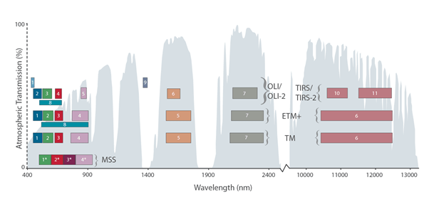
The Multispectral Scanner System (MSS) aboard Landsats 1–5 had four bands. The Thematic Mapper (TM) aboard Landsats 4 & 5 had seven bands. Landsat 7’s Enhanced Thematic Mapper Plus (ETM+) has 8 bands and Landsats 8 & 9 have 11 bands. The atmospheric transmission values for this graphic were calculated using MODTRAN for a summertime mid-latitude hazy atmosphere (circa 5 km visibility).
Landsat 9 Band Combinations
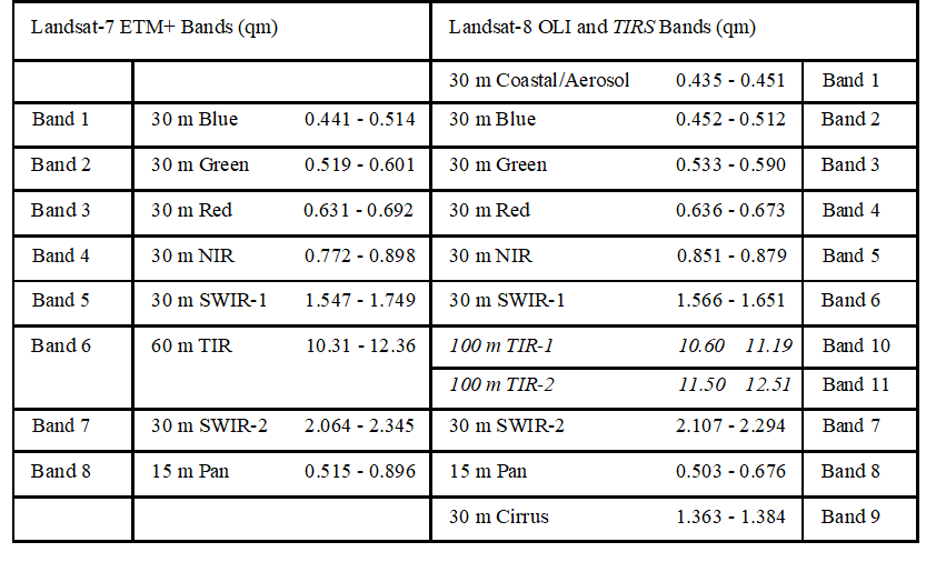
Landsat-7 Enhanced Thematic Mapper Plus (ETM+) | Landsat-8 Operational Land Imager (OLI) and Thermal Infrared Sensor (TIRS )
LANDSAT-5 & 4 Thematic Mapper (TM)
| Band Number | Description | Wavelength | Resolution |
| Band 1 | Visible blue | 0.45 to 0.52 µm | 30 meter |
| Band 2 | Visible green | 0.52 to 0.60 µm | 30 meter |
| Band 3 | Visible red | 0.63 to 0.69 µm | 30 meter |
| Band 4 | Near-infrared | 0.76 to 0.90 µm | 30 meter |
| Band 5 | Short-wave infrared | 1.55 to 1.75 µm | 30 meter |
| Band 6 | Thermal | 10.4 to 12.3 µm | 120 meter |
| Band 7 | Short-wave infrared | 2.08 to 2.35 µm | 30 meter |
Landsat 1-3 Multispectral Scanner (MSS)
| Band Number | Description | Wavelength | Resolution |
| Band 4 | Visible green | 0.5 to 0.6 µm | 60 meter |
| Band 5 | Visible red | 0.6 to 0.7 µm | 60 meter |
| Band 6 | Near-infrared | 0.7 to 0.8 µm | 60 meter |
| Band 7 | Near-infrared | 0.8 to 1.1 µm | 60 meter |
For Latest GIS Jobs: Click Here![]()
- West Bengal Map
- Geospatial Intelligence and Machine Learning Applications in the Air Force: An In-Depth Analysis
- Remote Sensing of Environment
- Geospatial Bill of India 2022
- Free online Remote Sensing and GIS Certification by IIRS-ISRO | 91th सुदूर संवेदन एवं जीआईएस प्रौद्योगिकी के मूल सिद्धांत पर दो सप्ताह का पाठ्यक्रम (सितंबर 14 -28, 2021)