Global Positioning System, also known as GPS, is a satellite-based navigation system that is used to determine the location and time information of an object or person on or near the Earth’s surface. GPS has become an essential tool for a variety of applications, from navigating a car to tracking wildlife movements.
History of GPS
The development of GPS began in the 1960s as a joint effort between the United States Department of Defense and the Aerospace Corporation. The first GPS satellite was launched in 1978, and the system became operational in 1995. Initially, GPS was used primarily for military purposes, but in the 1980s and 1990s, the system was made available for civilian use.
In 2000, President Bill Clinton announced that the U.S. government would stop degrading the GPS signal available to civilians, making it possible to receive more accurate location information. Since then, GPS has become an integral part of our lives, enabling us to navigate, track our movements, and access a wide range of location-based applications on our mobile devices.
How GPS Works
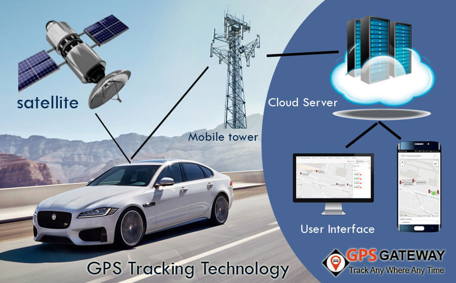
GPS works by transmitting signals from satellites in space to GPS receivers on the ground. The GPS satellites orbit the Earth at an altitude of about 20,000 kilometers, and they are spread out in six orbital planes. Each satellite continuously broadcasts signals that contain information about its location and the time the signal was transmitted. A GPS receiver on the ground receives the signal and calculates the time it took for the signal to travel from the satellite to the receiver. By using this information from multiple satellites, the GPS receiver can determine its own location on the Earth’s surface.
The GPS system consists of a network of at least 24 satellites in orbit around the Earth, ground control stations, and GPS receivers. The satellites continuously transmit signals containing their location and time information, which can be picked up by GPS receivers on the ground or in the air. By measuring the time delay between the transmission of a signal and its reception by a GPS receiver, the receiver can calculate its distance from the satellite. By receiving signals from multiple satellites, the GPS receiver can determine its own location on the Earth’s surface with high accuracy.
Applications of GPS
GPS has become an essential tool for many applications, including navigation, tracking, surveying, and mapping. In the automotive industry, GPS is used to provide turn-by-turn directions to drivers, and it can also be used to track the location of a vehicle in real-time. GPS is also used in aviation, where it is used for navigation and to provide accurate altitude and speed readings.
In addition to transportation, GPS is used for a variety of other applications. For example, GPS is used to track wildlife movements to better understand their behavior and migration patterns. GPS is also used in surveying and mapping, where it is used to accurately measure distances and create maps of the Earth’s surface.
GPS has numerous applications in various fields, including:
- Navigation: The most common application of GPS is navigation. It is used in cars, ships, aircraft, and handheld devices to provide accurate location information, directions, and real-time traffic updates.
- Mapping and Surveying: GPS is used extensively in surveying and mapping applications. It helps in creating accurate maps, monitoring land use changes, and surveying natural resources, such as forests and rivers.
- Agriculture: GPS is used in precision agriculture to improve crop yield, reduce waste, and optimize resource usage. It helps farmers to track crop growth, monitor soil moisture levels, and apply fertilizers and pesticides accurately.
- Emergency Services: GPS is used in emergency services to locate and rescue people in distress. It helps in tracking lost hikers, locating missing persons, and providing accurate location information to emergency responders.
- Fleet Management: GPS is used in fleet management to track the movement of vehicles, monitor driver behavior, and optimize routes. It helps in reducing fuel costs, increasing productivity, and improving safety.
- Aviation: GPS is used in aviation for navigation, air traffic control, and precision landing. It helps in improving safety, reducing flight times, and minimizing delays.
- Geocaching: Geocaching is a popular outdoor activity that involves using GPS to find hidden containers or “caches” in various locations around the world.
- Sports and Fitness: GPS is used in sports and fitness applications to track workouts, monitor heart rate, and measure performance metrics. It helps athletes to train more efficiently, set and achieve goals, and improve overall fitness.
- Scientific Research: GPS is used in scientific research to track animal movements, monitor changes in the environment, and study climate change. It helps in understanding the natural world, predicting future trends, and making informed policy decisions.
- Military and Defense: GPS is used by the military for navigation, reconnaissance, and targeting. It helps in improving situational awareness, enhancing mission effectiveness, and reducing the risk of friendly fire.
Limitations of GPS
While GPS has revolutionized navigation and location-based services, it does have some limitations. One of the primary limitations is that GPS signals can be blocked or degraded by buildings, trees, and other obstructions. This can result in inaccurate location information or the loss of the GPS signal altogether. GPS is also vulnerable to interference from other radio signals, which can disrupt the GPS signal and make it unusable.
Advancements in GPS Technology
Since the initial development of GPS, there have been significant advancements in GPS technology. In addition to the original GPS system developed by the United States, there are now several other satellite-based navigation systems, including IRNSS or NAVIC (India), GLONASS (Russia), Galileo (European Union), and Beidou (China).
The accuracy of GPS has also improved significantly over time. The original GPS system was accurate to within about 100 meters, but today’s GPS receivers can achieve accuracy within a few centimeters. This improved accuracy has opened up new applications for GPS, including precision agriculture, where GPS is used to guide tractors and other farm equipment.
Future of GPS
As technology continues to evolve, the future of GPS looks bright. There are ongoing efforts to improve the accuracy and reliability of GPS, including the development of new satellite systems and ground-based augmentation systems.
In addition to improvements in accuracy, there is also ongoing research into new applications for GPS. For example, GPS is being used to track the movements of animals and to study the effects of climate change on wildlife populations. GPS is also being used to monitor the movement of people and goods, which could have significant implications for logistics and transportation.
GPS in Everyday Life
GPS has become a ubiquitous technology in our everyday lives. It is integrated into our smartphones, cars, and even wearable devices. GPS-enabled apps such as Google Maps, Apple Maps, and Waze have made it easier than ever to navigate and explore our surroundings. GPS is also used in fitness trackers to monitor our activity levels and track our workouts.
In the automotive industry, GPS is used not only for navigation but also for vehicle tracking and fleet management. GPS tracking devices can be installed in vehicles to monitor their location, speed, and other information in real-time, which can help companies optimize their logistics and transportation operations.
In emergency situations, GPS can be a lifesaving technology. First responders can use GPS to locate and rescue people who are lost or injured in remote areas. GPS can also be used to track the movements of people with cognitive impairments or dementia who may wander away from home.
GPS and Privacy
While GPS has many benefits, it also raises privacy concerns. GPS-enabled devices and apps can track our location and movements, which can be a concern for those who value their privacy. There have been several high-profile cases of GPS tracking being used for surveillance, such as in law enforcement investigations or by stalkers.
To address these concerns, there are laws and regulations in place to protect individuals’ privacy rights. For example, in the United States, the Fourth Amendment of the Constitution protects individuals from unreasonable searches and seizures, including the use of GPS tracking without a warrant.
GPS and Geocaching
Geocaching is a popular outdoor activity that involves using GPS to find hidden containers or “caches” in various locations around the world. Geocachers use GPS coordinates to navigate to the cache location, where they must use their problem-solving skills to find the cache hidden in the area.
Geocaching has become a global phenomenon, with millions of active geocachers and caches located in nearly every country in the world. Geocaching is a fun and exciting way to explore new places, connect with others, and enjoy the outdoors.
GPS and Scientific Research
GPS has also become an important tool in scientific research, enabling scientists to track the movements of animals, study changes in the Earth’s crust, and monitor changes in the atmosphere and oceans. GPS tracking devices can be attached to animals, such as birds, sea turtles, and whales, to monitor their movements and migration patterns.
GPS is also used to study the effects of climate change on the environment. By tracking the movement of ice sheets and glaciers, scientists can better understand how the Earth’s climate is changing over time. GPS can also be used to monitor changes in sea level, ocean currents, and weather patterns.
GPS and the Future of Transportation
GPS is expected to play an increasingly important role in the future of transportation. Self-driving cars, for example, rely on GPS and other sensors to navigate and avoid obstacles. GPS can also be used to optimize traffic flow and reduce congestion on roads.
In the aviation industry, GPS is used for navigation and to improve the accuracy of flight paths. GPS-based systems can help reduce the risk of collisions and improve the efficiency of air traffic control.
Conclusion
GPS has revolutionized the way we navigate and understand the world around us. From its humble beginnings as a military navigation system, GPS has become an essential tool for a wide range of applications, from automotive navigation to precision agriculture. As technology continues to evolve, it is likely that GPS will continue to play an important role in our lives, enabling us to explore and understand the world in new and exciting ways.
GPS has also become an essential tool in our everyday lives, enabling us to navigate, track our movements, and access a wide range of location-based services. While there are privacy concerns associated with GPS, there are also laws and regulations in place to protect individuals’ privacy rights. As technology continues to evolve, it is likely that GPS will continue to play an important role in our lives, helping us to explore and understand the world around us while respecting our privacy and personal rights.
List of GPS devices with their features and specifications:
- Garmin GPSMAP 66i: The Garmin GPSMAP 66i is a handheld GPS device with a 3-inch color display and satellite communication capabilities. It comes preloaded with TOPO maps and can be used for navigation, tracking, and communication in remote areas. The device has a high-sensitivity GPS receiver and supports multiple positioning systems, including GPS, GLONASS, and Galileo. It also has a two-way messaging feature, allowing users to send and receive messages via satellite.
- TomTom GO Navigation: The TomTom GO Navigation is a car GPS device with real-time traffic updates, voice-activated navigation, and speed camera alerts. It comes with preloaded maps of North America and can be updated over Wi-Fi. The device has a 5-inch touchscreen display and supports hands-free calling and smartphone integration. It also provides access to TomTom Road Trips, a platform for discovering and planning scenic routes.
- Magellan TR5: The Magellan TR5 is a GPS device designed for off-road navigation. It comes with topographic maps, trail maps, and satellite imagery, making it ideal for exploring trails, mountains, and forests. The device has a 5-inch color touchscreen display and supports turn-by-turn directions and route planning. It also provides access to social media sharing and weather updates.
- Wahoo ELEMNT ROAM GPS Bike Computer: The Wahoo ELEMNT ROAM is a GPS device for cyclists, with turn-by-turn directions, route planning, and real-time ride tracking. It has a 2.7-inch color display and supports smartphone integration for wireless data transfer and call/text notifications. The device is compatible with both ANT+ and Bluetooth sensors, allowing users to monitor heart rate, cadence, and other performance metrics.
- Bad Elf GPS Pro+: The Bad Elf GPS Pro+ is a portable GPS device with a high-performance GPS receiver, multiple positioning systems, and long battery life. It has a 2.5-inch color display and can be used for navigation, tracking, and mapping. The device supports both NMEA and Bluetooth data output and can be used with a variety of mobile devices, including iOS, Android, and Windows.
- Humminbird HELIX 5 CHIRP GPS G2: The Humminbird HELIX 5 CHIRP GPS G2 is a fishfinder GPS device for marine navigation, with CHIRP sonar, down imaging, and lake maps. It has a 5-inch color display and supports multiple sonar frequencies and modes. The device comes with AutoChart Live, a feature that allows users to create custom maps of their favorite fishing spots.
- Apple Watch Series 6: The Apple Watch Series 6 is a smartwatch with built-in GPS, heart rate monitor, and fitness tracking features. It has a Retina display and supports wireless data transfer and call/text notifications. The device can be used for outdoor activities, such as running, cycling, and swimming, and provides access to Apple’s ecosystem of apps and services.
- Spot Gen4: The Spot Gen4 is a GPS device for outdoor adventures, with satellite communication capabilities, SOS button, and tracking features. It can be used for tracking, messaging, and emergency response in remote areas. The device has a compact and rugged design and comes with a long battery life. It also provides access to Spot’s tracking platform, allowing users to share their location with friends and family.
- DJI Phantom 4 Pro: The DJI Phantom 4 Pro is a drone with GPS navigation, obstacle avoidance, and 4K camera for aerial photography and videography. It has a 7-kilometer control range and can fly for up to 30 minutes on a single charge. The device has a GPS-based navigation system, allowing it to fly and hover in place with great precision. It also has obstacle avoidance sensors, making it safer to fly in complex environments. The camera on the Phantom 4 Pro can shoot 4K video at 60 frames per second and capture 20-megapixel photos. It also supports multiple shooting modes, including burst mode, time-lapse, and HDR.
- Garmin inReach Mini: The Garmin inReach Mini is a compact handheld GPS device with satellite communication capabilities, messaging, and location tracking. It can be used for navigation, tracking, and communication in remote areas. The device has a 1.27-inch display and comes with a rechargeable battery that can last up to 90 hours in tracking mode. It also supports two-way messaging and can be used with the Earthmate app to download maps and plan routes. The device has an SOS button, allowing users to send an emergency signal to GEOS, a global emergency response center.