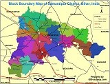
Block Boundary, Rail, Road, sub-division Map of Samastipur District of Bihar State, India.
Table of Contents
Samastipur map 🗺 like Road, Rail, block list, sub-division, Village, Tehsil maps. which can be 🗺 download in pdf and jpeg format as well as Block Boundary in shapefile format from here. you can also request other information via comments as per your requirements (like tourism purposes).
Samastipur 6th in terms of population (42,61,566) and 14th in terms of area (2,904 sq.km.) in the state of Bihar. In terms of population per sq.km. Samastipur is the 10th densely populated district in the state with 1,467 persons per sq.km as against the state’s 1,106. Samastipur ranks 22nd in terms of sex-ratio (911) against the state’s 918.
Samastipur ranks 30th in terms of child sex-ratio (923) against state’s 935. There are 117 uninhabited villages (out of 1,246 total villages) in the district of Samastipur. Bibhutipur (under Bibhutipur C.D. Block) is the most
populated village (34,764) and Bhatgawan (under Hasanpur C.D. Block) is the least populated village (1) in the district.
C.D. Block Kalyanpur has the highest number of villages (152) in the district and C.D. Block Mohanpur has the lowest number of villages (33).
Raspur Patasia (under Mohiuddinagar C.D. Block) has the largest area (3,476 hectares) and Ram Paran Andar (under Kalyanpur C.D. Block) and Surajpur (under Ujiarpur C.D. Block) have the smallest area (1 hectare each) among the villages in the district.
Samastipur district came into existence on 14 November 1972 by separating from the erstwhile Darbhanga district. Now, Samastipur comes under Darbhanga commissionary.
Presently there are total 4 sub-divisions in the Samastipur district which are Samastipur, Rosera, Dalsinghsarai, and Patori.
There are 20 CD Blocks, 3 Nagar Parishads / Nagar Panchayats, 381 Panchayats, and 1260 Revenue Villages in the district with their district headquarters at Samastipur.
Samastipur Block (Tehsil) List
| Sl. No | Sub-Division | Block |
| 1. | Samastipur | Samastipur |
| 2. | Samastipur | Tajpur |
| 3. | Samastipur | Morwa |
| 4. | Samastipur | Khanpur |
| 5. | Samastipur | Sarairanjan |
| 6. | Samastipur | Pusa |
| 7. | Samastipur | Warishnagar |
| 8. | Samastipur | Kalyanpur |
| 9. | Rosera | Rosera |
| 10. | Rosera | Hasanpur |
| 11. | Rosera | Bithan |
| 12. | Rosera | Shivajinagar |
| 13. | Rosera | Singhiya |
| 14. | Rosera | Bibhutipur |
| 15. | Dalsingsarai | Dalsingsarai |
| 16. | Dalsingsarai | Ujiyarpur |
| 17. | Dalsingsarai | Vidyapatinagar |
| 18. | Patori | Patori |
| 19. | Patori | Mohanpur |
| 20. | Patori | Mohiuddin Nagar |
समस्तीपुर तहसील लिस्ट | Samastipur Tehsil List in Hindi
| क्र. म. | तहसील अंचल लिस्ट (Tehsil List) |
| 1. | समस्तीपुर |
| 2. | ताजपुर |
| 3. | मोरवा |
| 4. | खानपुर |
| 5. | सरायरंजन |
| 6. | पूसा |
| 7. | वारिसनगर |
| 8. | कल्यानपुर |
| 9. | रोसड़ा |
| 10. | हसनपुर |
| 11. | बिथान |
| 12. | शिवाजीनगर |
| 13. | सिंघिया |
| 14. | बिभूतिपुर |
| 15. | दलसिंगसराय |
| 16. | उजियारपुर |
| 17. | विद्यापतिनगर |
| 18. | पटोरी |
| 19. | मोहनपुर |
| 20. | मोहिउद्दीननगर |
- Government GIS Jobs in India
- GIS Jobs in Bangalore
- GIS Jobs in Hyderabad/ Secunderabad
- GIS Jobs in Delhi/Gurgaon/Noida
- GIS Jobs in Mumbai/Maharashtra
- GIS Jobs in Kolkata
- GIS Jobs in Pune
- GIS Jobs in Chennai
FAQ
Samastipur district block list?
1. Bibhutipur
2. Bithan
3. Rosera
4. Samastipur
5. Shivajinagar
6. Singhiya
7. Tajpur
8. Ujiyarpur
9. Vidyapatinagar
10. For all block click here
Samastipur road map?
You can download the Samastipur road map 🗺 click here
Samastipur Map pdf
You can download a pdf map of the Samastipur by 🗺 click here
Samastipur Tehsil List
समस्तीपुर
ताजपुर
मोरवा
खानपुर
सरायरंजन
पूसा
वारिसनगर
कल्यानपुर
रोसड़ा
सभी तहसील के लिए क्लिक करे